Wildfire Risk in Santa Monica Mountains and Ventura County
Wildfire Risk in Santa Monica Mountains and Ventura County. Several studies and reports provide detailed assessments of wildfire damage potential in these regions
Overview of Wildfire Risk in Santa Monica Mountains and Ventura County
Southern California, particularly the Santa Monica Mountains and Ventura County areas, faces exceptionally high wildfire potential due to a combination of factors including Mediterranean climate with prolonged dry seasons, flammable shrubland vegetation like chaparral and coastal sage scrub, steep topography, and strong Santa Ana winds that drive rapid fire spread and ember spotting. Historical records show large, high-intensity wildfires have been a natural part of the landscape for centuries, predating modern fire suppression, with events often exceeding 10,000 hectares under extreme weather conditions. Recent analyses indicate that climate change is exacerbating these risks through increased drought severity, delayed precipitation, and higher temperatures, leading to critically dry fuels and more frequent megafires (over 50,000 hectares). In Ventura County, wildfire probability is rated medium-to-high, with fires over 1,000 acres occurring every 1-3 years, and Very High Fire Hazard Severity Zones (FHSZ) covering 504 square miles, especially in mountainous and wildland-urban interface (WUI) areas. The Santa Monica Mountains are particularly vulnerable due to their proximity to urban development, where human ignitions near roads and trails amplify risks.
Key Studies and Analyses
Several studies and reports provide detailed assessments of wildfire damage potential in these regions:
- Wildfire Risk Prediction and Assessment in Los Angeles and Ventura Counties (2025): This GIS-based study used weighted overlay analysis of factors like topography, climate, soil, and building proximity to map risk zones. It found 25.1% of buildings (about 99,711) in high-risk areas, with strong correlations to historical fire perimeters in the Santa Monica Mountains and Topanga Canyon. High-risk zones are concentrated in mountainous WUI areas, with model accuracy at 78.96%. Conclusions emphasize restricting development in high-risk corridors and enhancing defensible space to mitigate urban expansion's role in increasing vulnerability.
- Predicting Spatial Patterns of Fire on a Southern California Landscape (2010): Focused on the Santa Monica Mountains, this model predicts fire ignitions are human-driven and clustered near infrastructure (roads, trails, housing), while fire frequency is influenced by biophysical variables like minimum temperature, aspect, elevation, and slope. High-risk areas include coastal and interior canyons with warmer, drier conditions, where fires spread farther from urban areas due to continuous vegetation and limited suppression. The study recommends targeted management in these zones to reduce ignition sources.
- Large, High-Intensity Fire Events in Southern California Shrublands (2009): This historical analysis debunks the idea that modern fire suppression caused large fires, showing 19th-century events like the 1878 Tujunga Canyon Fire (24,100 ha) and 1889 Santiago Canyon Fire (125,000–200,000 ha) were wind-driven and massive. In the Santa Monica Mountains, young fuels (under 20-30 years) are highly flammable due to dense fine dead materials, with no significant difference between chaparral and sage scrub. Recent megafires are linked to extreme droughts increasing dead fuels and spotting, rather than fuel age accumulation.
- Large Wildfire Potential, Santa Monica Mountains Region (2021): A 30-meter resolution raster dataset models relative large wildfire risk using variables like topographic heterogeneity, Santa Ana wind speed, elevation, and proximity to infrastructure. It shows elevated potential across the Santa Monica Mountains, with a cross-validated accuracy of 86%, highlighting areas for broad-scale management but not individual fire prediction.
- Ventura County Community Wildfire Protection Plan (2023): This plan assesses risks in Ventura County, identifying Very High FHSZ in areas like Thousand Oaks, Simi Valley, Moorpark, and unincorporated communities (e.g., Bell Canyon, Piru, Oak Park) due to chaparral-covered hills and WUI exposure. Recent fires like the Thomas (281,893 acres) and Woolsey (96,949 acres) underscore wind-driven threats. Recommendations include fuels reduction (e.g., prescribed burns, mechanical treatments), defensible space ordinances (100-foot zones with sub-zones for vegetation management), community education (e.g., Ready, Set, Go! programs), and equity-focused outreach for vulnerable populations like non-English speakers and low-income residents.
- Social Inequity and Wildfire Response in Ventura County (2024): Spatial analysis identifies marginalized communities (e.g., in Santa Paula and Piru) at higher risk due to limited resources and underrepresentation in planning. It links social vulnerability to increased wildfire impacts and recommends expanding mitigation programs, community engagement, and resource allocation to build resilience.
Recent Events and Atmospheric Drivers
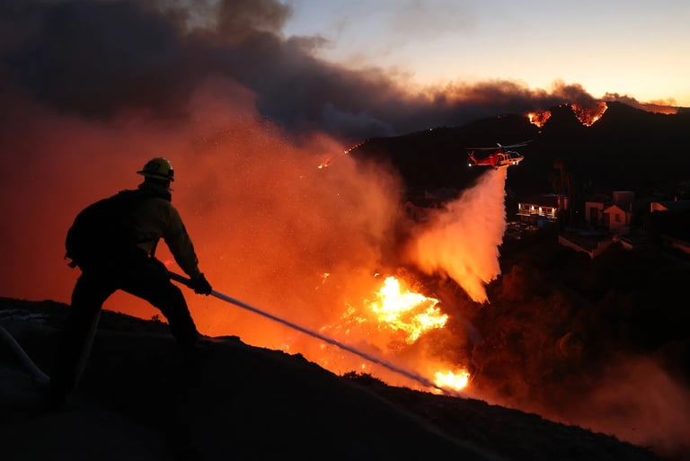
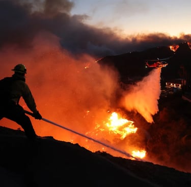
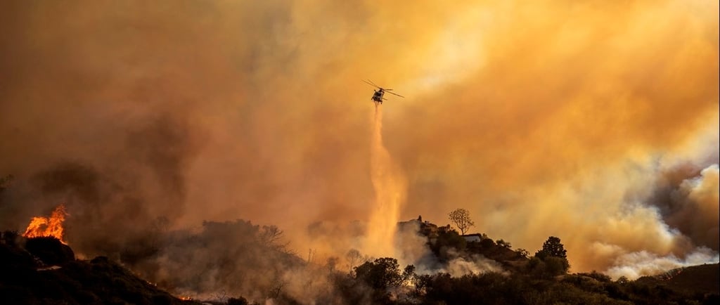
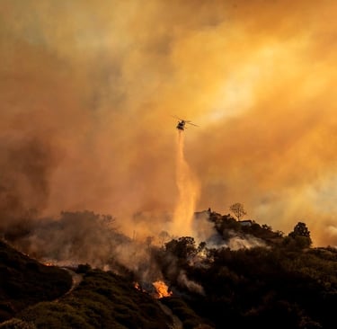
The 2025 Los Angeles fires exemplify these risks, with the Palisades Fire burning 23,707 acres in the Santa Monica Mountains and the earlier Mountain Fire scorching over 19,000 acres in Ventura County. These were driven by a "jet-forced Santa Ana" wind event with gusts up to 85 mph, critically low humidity (<20%), and delayed precipitation (second-latest onset since 1948), leading to dry live fuels below 60% moisture. The events destroyed over 16,000 structures and caused 31 fatalities, highlighting compounding factors like urban exposure and drought. Similar conditions fueled the 2017 Thomas Fire in Ventura County, ignited during prolonged Santa Ana winds. Recent X posts from weather authorities like NWS Los Angeles warn of ongoing high wind and red flag conditions in these areas, increasing rapid fire spread potential.
Mitigation and Future Outlook
Experts note these risks are "entirely foreseeable," with Los Angeles County ranking in the 99th percentile for wildfire exposure nationwide. Initiatives like the Santa Monica Mountains Woolsey Fire Recovery Program and UCLA's Reducing Wildfire Risk project focus on resilient land management, such as fuels treatments and ecosystem adaptation. The 2005 Fire Management Plan for Santa Monica Mountains emphasizes flexible strategies including prescribed burns and WUI fuel reduction. Overall, studies stress integrated approaches: limiting WUI development, improving evacuation planning, and addressing social inequities to reduce damage potential amid climate-driven intensification.
Here are the key sources referenced in the analysis on high wildfire damage potential in the Santa Monica Mountains and Ventura County areas. They are organized by topic/study for clarity, including direct links to articles, studies, reports, and related resources (primarily peer-reviewed papers, government plans, and scientific publications from 2008–2025). These provide evidence-based assessments of risks, historical patterns, modeling, and recent events.
Key Studies and Analyses
- Wildfire Risk Prediction and Assessment in Los Angeles and Ventura Counties, California (2025 GIS-based study on risk zones, building exposure, and mitigation needs):
(Also available via ResearchGate: https://www.researchgate.net/publication/395311742_Wildfire_Risk_Prediction_and_Assessment_in_Los_Angeles_and_Ventura_Counties_California)
- Predicting Spatial Patterns of Fire on a Southern California Landscape (2008/2010 study focused on ignitions and frequency in the Santa Monica Mountains):
(PDF version: https://silvis.forest.wisc.edu/wp-content/uploads/pubs/SILVIS/Syphard_etAl_IJWF_2008.pdf)
- Large, High-Intensity Fire Events in Southern California Shrublands: Debunking the Fine-Grain Age Patch Model (2009 historical analysis of large fires in shrublands, including pre-suppression events):
https://esajournals.onlinelibrary.wiley.com/doi/abs/10.1890/08-0281.1
(PubMed abstract: https://pubmed.ncbi.nlm.nih.gov/19323174)
- Large Wildfire Potential, Santa Monica Mountains Region, CA (2021 modeled raster dataset for large fire potential using variables like winds, topography, and infrastructure):
https://databasin.org/datasets/00c8d5aa2a8344498a1576f700a2a42d
- Ventura County Community Wildfire Protection Plan (2023 county-wide plan assessing risks, Very High FHSZ areas, historical fires like Thomas and Woolsey, and mitigation recommendations):
https://s48417.pcdn.co/wp-content/uploads/2024/04/Ventura-County-CWPP-Final-2023-signed.pdf
(Additional localized versions, e.g., Rancho Ventura: https://venturafiresafe.org/wp-content/uploads/2025/06/RVCT-CWPP-Final-2023-signed.pdf)
- Social Inequity and Wildfire Response: Identifying Gaps and Interventions in Ventura County, California (2024 spatial analysis linking marginalization, vulnerability, and wildfire risk):
https://www.mdpi.com/2571-6255/7/2/41
Recent Events and Atmospheric/Compound Risk Analyses
- Compound Atmospheric Drivers of the Catastrophic 2025 Los Angeles Urban Firestorm (2025 Nature study on the Palisades, Eaton, and related fires, including Mountain Fire in Ventura County, driven by jet-forced Santa Ana winds and delayed rain):
https://www.nature.com/articles/s44304-025-00155-7
- CAL FIRE 2025 Incident Archive (official records for 2025 fires, including Palisades Fire [23,448 acres in Santa Monica Mountains area] and Mountain Fire):
https://www.fire.ca.gov/incidents/2025
- 'Entirely Foreseeable': The L.A. Fires Are the Worst-Case Scenario Experts Feared (2025 NBC News article on foreseeable risks in high-hazard zones like Pacific Palisades and Santa Monica Mountains):
These sources draw from geospatial modeling, historical data, climate analysis, and official plans to highlight the elevated risks from vegetation, winds, urban-wildland interfaces, and climate trends in these regions.