New Unified Park Closure Protocol for So Cal
Santa Monica Mountains National Recreation Area Implements New Unified Park Closure Protocol for Red Flag Warnings
Santa Monica Mountains National Recreation Area Implements New Unified Park Closure Protocol for Red Flag Warnings
By Fast Fire Network Staff
March 29, 2026
In a significant step toward coordinated wildfire prevention in one of Southern California’s most fire-prone regions, the four primary agencies managing the Santa Monica Mountains National Recreation Area (SMMNRA) have released a new joint protocol for park and trail closures during National Weather Service Red Flag Warnings.
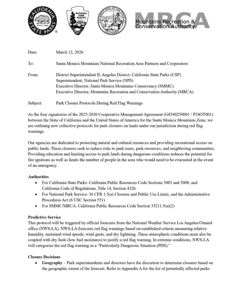
The memorandum, dated March 12, 2026, and signed by top officials from California State Parks (CSP), the National Park Service (NPS), the Santa Monica Mountains Conservancy (SMMC), and the Mountains Recreation and Conservation Authority (MRCA), standardizes how closures will be handled across more than 150,000 acres of public lands in the Santa Monica Mountains Zone.
The announcement was shared publicly on March 24 via the official L.A. Mountains Facebook page and agency websites, complete with the full four-page signed document and Appendix A listing potentially affected sites.
Why This Protocol Matters
The Santa Monica Mountains are a high-risk wildfire corridor. Chaparral vegetation, steep terrain, and notorious Santa Ana winds have fueled some of the region’s most destructive fires. Human-caused ignitions remain a leading factor in many incidents, especially during extreme fire weather.
The agencies state their goal clearly:
“These closures seek to reduce risks to park users, park resources, and neighboring communities. Providing education and limiting access to park lands during dangerous conditions reduces the potential for fire ignitions as well as limits the number of people in the area who would need to be evacuated in the event of an emergency.”
This unified approach replaces previous agency-by-agency decisions with a consistent, predictable framework under the 2025–2030 Cooperative Management Agreement.
How the Protocol Works
Trigger: An official Red Flag Warning (or “Particularly Dangerous Situation” designation) issued by the National Weather Service Los Angeles/Oxnard office (NWS-LA). Criteria include low humidity, high sustained winds and gusts, dry lightning, and critically low fuel moisture.
Decision Process: Park superintendents and directors retain discretion to determine the geographic scope of closures based on the forecast. Decisions are made daily, ideally announced the day prior. Even a partial-day forecast triggers a full-day closure.
Legal Authorities:
- California State Parks: Public Resources Code §§ 5003, 5008; Title 14 CCR § 4326
- National Park Service: 36 CFR 1.5(a) and Administrative Procedures Act
- SMMC/MRCA: Public Resources Code § 33211.5(a)(2)
What’s Closed vs. What Stays Open
Closed or Cancelled (at superintendent/director discretion):
- All trails
- Undeveloped and backcountry areas
- Visitor centers
- Events, programs, school field trips, and volunteer activities
- Many parking lots (including NPS lots)
- Certain facilities during extreme “PDS” conditions
Open and Accessible:
- Roads (unless behind a locked gate)
- California State Parks developed parking lots
- Roadside overlooks (unless signed closed)
- Campgrounds (with standard evacuation and hazard messaging in effect)
Beach sites are generally exempt unless specific hazards exist.
Potentially Affected Sites (Appendix A Summary)
California State Parks:
- Topanga State Park
- Malibu Creek State Park
- Leo Carrillo State Park
- Point Mugu State Park
- Will Rogers State Historic Park
- Santa Susana Pass State Historic Park
National Park Service (partial list):
- Rancho Sierra Vista, Solstice Canyon, Peter Strauss Ranch, Cheeseboro/Palo Comado, Circle X Ranch, Backbone Trail, Sandstone Peak/Mishe Mokwa, and many others.
SMMC/MRCA (partial list, with some sites outside NRA boundary):
- Temescal Canyon Park, Corral Canyon Park, Upper Las Virgenes Canyon Open Space Preserve, Westridge-Canyonback Wilderness Park, and more.
The full list is in Appendix A of the official document.
Public Messaging and Talking Points
To avoid confusion, all agencies will use consistent language such as:
“Parks within Santa Monica Mountains National Recreation Area are closed. The National Weather Service has issued a red flag warning based on weather and fuel conditions. This closure applies to lands managed by California State Parks, National Park Service, Santa Monica Mountains Conservancy, and Mountains Recreation and Conservation Authority.”
Key safety message:
“This is NOT a good time to be hiking, biking, horseback riding, or picnicking in the mountains. Staying out of the area reduces the chance of accidentally starting fires. It also reduces the number of people who would need to be evacuated in the event of an emergency.”
Where to Stay Informed
- Full official protocol (PDF): [parks.ca.gov Red Flag Warning Protocol March 2026](https://www.parks.ca.gov/pages/681/files/Red%20Flag%20Warning%20Protocol%20March%202026%20SIGNED.pdf) or [mrca.ca.gov version](https://mrca.ca.gov/wp-content/uploads/2026/03/Red-Flag-Warning-Protocol-March-2026-SIGNED.pdf)
- Check NWS Los Angeles/Oxnard for current warnings
- Monitor agency websites: mrca.ca.gov, smmc.ca.gov, parks.ca.gov, nps.gov/samo
- Follow L.A. Mountains on Facebook and Instagram for real-time updates
Bottom Line for Fire-Smart Residents and Visitors
This protocol is a proactive, common-sense measure that prioritizes prevention over reaction. Keeping people out of the backcountry during peak fire weather directly lowers ignition risk and protects lives, homes, and the iconic Santa Monica Mountains landscape.
Know before you go. When a Red Flag Warning is issued, plan your outdoor activities elsewhere. Your cooperation helps protect the very places we all love to enjoy—when conditions are safe.
Fast Fire Network will continue monitoring fire weather and agency updates in the Santa Monica Mountains and across Southern California.