
Fuels Reduction and Resilience Building in the Santa Monica's
Over 300 projects statewide to move forward in as little as 30 days
Fast Fuels Reduction and Resilience Building in the Santa Monica Mountains: On-the-Ground Progress After the 2025 Palisades Fire
The Santa Monica Mountains — with their iconic chaparral-covered ridges, steep canyons, and wildland-urban interface communities — remain one of Southern California’s most persistent high-risk wildfire zones. Following the destructive Palisades Fire in January 2025, which scorched significant acreage and threatened thousands of homes in areas like Pacific Palisades, Topanga, and Malibu, local agencies have moved aggressively into prevention mode.
While no major wildfires are currently burning in the range as of late March 2026, a wave of funded projects, fast-tracked approvals, and targeted investments is reshaping how the region prepares for the next ignition. These supporting efforts — centered on hazardous fuels reduction, workforce readiness, structure protection, and real-time monitoring — offer valuable lessons for rapid-response wildfire networks nationwide.
Fast-Tracking Fuels Reduction: From Years to Weeks
One of the most visible shifts is the dramatic acceleration of wildfire safety projects across California, including in the Santa Monica Mountains. Governor Newsom’s emergency proclamation has enabled over 300 projects statewide to move forward in as little as 30 days — a process that previously could take a year or more.
In the Santa Monica Mountains zone, the Mountains Recreation and Conservation Authority (MRCA) is leading a standout 600+ acre collaborative fuels reduction project near the 2025 Palisades Fire footprint. This effort focuses on strategic areas to protect adjacent communities by removing flashy, non-native vegetation and creating defensible space.
Additional on-the-ground work includes:
- Fuels reduction along high-risk corridors such as Santa Maria Road and the Summit to Summit Fire Road.
- Targeted treatments in Topanga Canyon and the Upper Las Virgenes Canyon Open Space Preserve, where crews are building fire breaks and clearing vegetation near homes that hadn’t seen major fire activity in decades.
- Roadside clearing and fuel breaks using methods like mowing and prescribed grazing to reduce continuous fuel loads.
These projects are supported by early-action funding from Proposition 4 (Climate Bond), which has unlocked millions specifically for the Santa Monica Mountains Conservancy (SMMC) zone. The fast-track approach allows agencies to act before the peak Santa Ana wind season returns, directly addressing the rapid fire-spread potential in this rugged terrain.
For FastFireNetwork readers, the key takeaway is speed: When detection systems flag an ignition in a treated zone, the reduced fuel continuity can buy critical minutes — or even hours — for containment.
Major Grant Funding Driving Local Action
Funding has been a game-changer. In February 2026, the Santa Monica Mountains Conservancy approved over $3.6 million in Prop 4 Climate Bond funds for wildfire prevention in the Los Angeles area. These grants break down as follows for the MRCA:
- $2,065,500 — Reduction of flashy non-native fuels, creation of defensible space around structures, and removal of hazard trees.
- $590,000 — Workforce development to train and deploy “fire-ready” crews for vegetation management, wildfire readiness, and initial suppression.
- $344,500 — Structure hardening and renovations to crew accommodations, enabling better surge capacity during Red Flag events.
Additionally, the Conservancy awarded $649,322 to the Ventura County Fire Protection District for targeted fuel reduction, including fuel breaks, prescribed grazing, and roadside clearing on the Ventura side of the Santa Monica Mountains.
Earlier grants in 2025 laid the groundwork, including $3.2 million split between Los Angeles County and Ventura County Fire Departments for immediate prevention work in high-risk parks, open spaces, and WUI areas near communities like Malibu, Calabasas, Agoura Hills, and Thousand Oaks.
The Regional Forest and Fire Capacity (RFFC) Program continues to support shovel-ready projects, with MRCA receiving $1.425 million in one recent CAL FIRE block grant allocation for landscape-level wildfire prevention.
These investments are not one-off; they represent a sustained push to build long-term resilience in a landscape defined by dense vegetation, steep slopes, and proximity to millions of residents.
Building the Workforce and Supporting Infrastructure
Effective fuels work requires skilled people on the ground — and Prop 4 funding is addressing that gap head-on. The $590,000 workforce grant to MRCA funds training for seasonal firefighters and vegetation management crews, including basic and advanced fire training, drills, and hands-on fuel removal.
Improved crew facilities (via the $344,500 structure hardening allocation) ensure teams can respond quickly during high-danger periods without logistical bottlenecks.
This human element pairs naturally with technology. Trained crews using drones for pre- and post-treatment mapping, or integrated with real-time sensor data, can maximize the impact of every dollar spent.
Live Fuel Moisture Monitoring: Data-Driven Decision Making
Prevention isn’t just about clearing brush — it’s about knowing exactly when the landscape becomes critically flammable. Los Angeles County Fire Department continues routine live fuel moisture (LFM) sampling in the Santa Monica Mountains, with recent March 2026 readings showing variability across key species like chamise and ceanothus.
Sites such as Clark Motorway (Malibu), Stunt Road (Calabasas), and Trippet Ranch (Topanga) are regularly monitored. While current levels are not yet at critical thresholds (generally considered around 60% for many chaparral species), the data helps agencies prioritize treatment zones and anticipate fire behavior under Santa Ana conditions.
For a FastFireNetwork audience, this ongoing monitoring highlights opportunities for AI-enhanced predictive modeling. Integrating LFM data with weather stations, satellite imagery, and ground sensors could create hyper-local ignition risk dashboards — turning raw numbers into actionable early warnings.
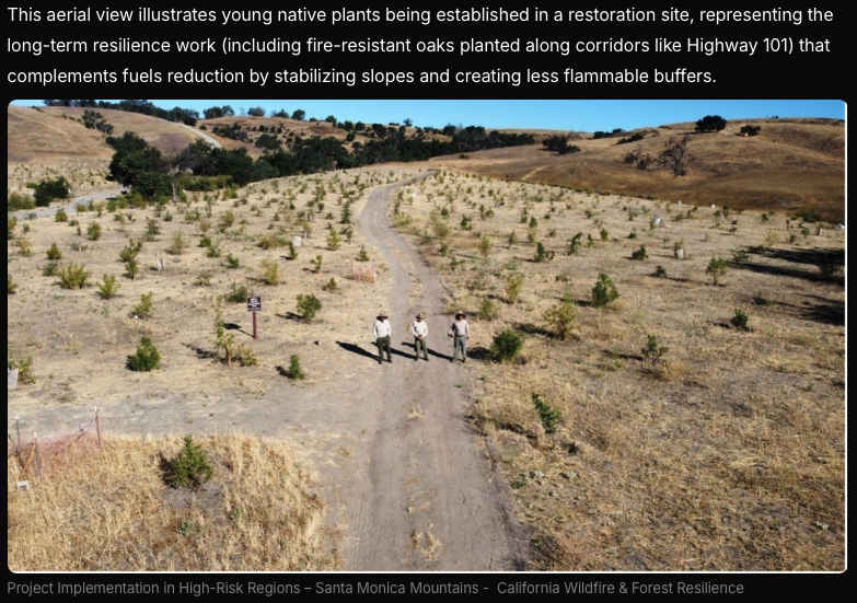
Planting for the Future: Fire-Resistant Vegetation and Habitat Restoration
Not all work is removal-focused. Along ignition-prone corridors like Highway 101, crews have planted thousands of fire-resistant oaks in recent years as part of broader resilience strategies. These native species can help stabilize slopes, reduce erosion after fires, and create less flammable buffers over time.
Post-2025 recovery efforts also include habitat restoration in burn scars, such as along Topanga Creek, to prevent mudslides while rebuilding ecological resilience.
Why These Efforts Matter for Fast Fire Response
The Santa Monica Mountains exemplify the challenges of fragmented jurisdictions — federal (National Park Service), state conservancies, county fire departments, local cities, and private landowners all manage pieces of the same high-risk landscape.
The surge in coordinated grants, fast-tracked projects, and shared funding streams is quietly building the infrastructure for faster, more unified action. When the next wind-driven event hits, treated acres, trained crews, and better data flows could mean the difference between a spot fire and a multi-thousand-acre disaster.
Opportunities for Innovation:
- Deploy sensor networks in recently treated fuel breaks to detect ignitions within seconds.
- Use AI to overlay LFM data with wind models for dynamic risk mapping.
- Integrate drone-based LiDAR for pre-treatment planning and post-treatment verification.
- Develop shared platforms that allow real-time data exchange across the patchwork of agencies operating in the mountains.
Looking Ahead
As California’s 2026 fire season approaches, the work underway in the Santa Monica Mountains shows what targeted, accelerated investment can achieve. Over $20 million from the Santa Monica Mountains Conservancy alone is supporting 16+ projects near the Palisades footprint, part of a larger $48+ million statewide conservancy push for Southern California resilience.
These supporting angles — fuels work, workforce building, monitoring, and restoration — form the foundation for meaningful risk reduction. For those in the fast fire detection and response space, the Santa Monica Mountains offer a real-world laboratory: Watch how these projects perform, identify tech gaps, and help scale solutions that keep communities safer.
FastFireNetwork will continue tracking these projects as they advance. Have insights from similar fuels reduction efforts or tech deployments in WUI zones? Share them in the comments or reach out — the conversation around faster, smarter wildfire resilience is only getting more urgent.
Full List of Primary Sources with Direct Links:
Palisades Fire – 23,448 acres: Official CAL FIRE incident page → https://www.fire.ca.gov/incidents/2025/1/7/palisades-fire
$3.6 million Prop 4 grants to MRCA (Feb 2026 breakdown): Wildfire Task Force announcement → https://wildfiretaskforce.org/california-awards-over-5-million-of-climate-bond-funds-for-local-wildfire-resilience-projects/
$3.2 million early-action grants (2025) & project locations (Santa Maria Road, Summit to Summit, Topanga, Upper Las Virgenes): MRCA Statewide Critical Fuel Reduction Projects page → https://mrca.ca.gov/statewide-critical-fuel-reduction-projects/
Hazardous fuel modification work in Topanga & Upper Las Virgenes: MRCA press release → https://mrca.ca.gov/press/hazardous-fuel-modification-work-begins-in-topanga-canyon-and-upper-las-virgenes-canyon-open-space-preserve/
600+ acre fuels reduction project & fast-tracking (300 projects in 300 days): Governor’s Office announcement → https://www.gov.ca.gov/2026/03/20/california-announces-300-wildfire-projects-fast-tracked-in-300-days/
MRCA RFFC / CAL FIRE block grant – $1.425 million: MRCA / LA Mountains announcement → https://www.facebook.com/lamountains/posts/the-mrca-awarded-seven-subgrants-from-a-cal-fire-pilot-regional-block-grant-that/1372399301593151/ (and related Instagram/MRCA posts)
Live Fuel Moisture sampling – March 2026 (Santa Monica Mountains sites: Clark Motorway, Stunt Road, Trippet Ranch): LA County Fire Department LFM Summary (PDF) → https://fire.lacounty.gov/wp-content/uploads/2026/03/01-LFM-Summary03182026.pdf
All sources are from official .ca.gov, .lacounty.gov, conservancy, or task force sites. They are current as of late March 2026 and provide the exact figures, breakdowns, and project details used in the article.