Flames of History
The Long, Fiery Chronicle of Wildfires in Southern California
Flames of History: The Long, Fiery Chronicle of Wildfires in Southern California
Southern California is a landscape born to burn. Its iconic chaparral-covered hills, coastal sage scrub, and oak woodlands thrive on periodic fire, yet the same conditions that sustain this Mediterranean ecosystem—prolonged dry seasons, drought, and the ferocious Santa Ana winds—also turn it into a tinderbox when ignitions occur. From ancient charcoal layers in lake sediments to the apocalyptic images of 2025’s urban conflagrations, fire has shaped the region for millennia. This long-form history traces Southern California wildfires from the earliest prehistoric evidence through the first European-recorded blazes to today’s record-shattering events, revealing how human practices, climate, and policy have transformed a natural cycle into an escalating crisis.
Prehistoric and Indigenous Fire Stewardship (13,000+ Years Ago to the 18th Century)
Charcoal records from Lake Elsinore and the Santa Barbara Basin paint a dramatic picture. Around 13,300 years ago, during the end of the last Ice Age, a spike in wildfires coincided with a 5.5°C temperature rise and a 200-year megadrought. These ancient blazes, likely amplified by human activity and declining megafauna (which once grazed down fuels), contributed to the extinction of large mammals like ground sloths and helped shift vegetation toward fire-adapted species that dominate today.
For at least the last 10,000–13,000 years, Indigenous peoples— including the Tongva (Gabrielino), Chumash, Luiseño, Cahuilla, and Kumeyaay—mastered “good fire.” They practiced sophisticated cultural burning: low-intensity, controlled fires set in small patches during cooler, moister seasons. These burns cleared underbrush, promoted nutrient-rich grasslands for hunting and gathering, stimulated acorn production from oaks, encouraged basketry materials like deer grass and sumac, and reduced the risk of catastrophic crown fires.
Estimates suggest that prior to Euro-American settlement (pre-1800 or pre-1850), 1.8 to 4.5 million acres burned annually across California, with peaks every 30 years or so reaching nearly 12 million acres. Fires often smoldered for months in a mosaic pattern that prevented massive, high-intensity events. This stewardship created the “park-like” landscapes that Spanish explorers marveled at in the late 1700s—open woodlands rather than impenetrable thickets. Fire was not an enemy but a tool for renewal, deeply embedded in cultural and spiritual practices.
Spanish, Mexican, and Early American Periods (1769–1880s): Transition and Early Documentation
The arrival of Spanish missionaries in 1769 marked the beginning of recorded observations, though systematic documentation was sparse. Expeditions noted occasional large burns, often lightning-caused or from Indigenous practices that continued initially. As missions and ranchos expanded, grazing by cattle and sheep altered fuel loads, and some fires were set deliberately for land clearing.
By the Mexican period (1821–1848) and early U.S. statehood after 1850, settlement increased. Ranchers and farmers sometimes ignited fires to improve pasture, but as populations grew in the Los Angeles Basin and coastal valleys, uncontrolled burns became a nuisance. One early documented event was a 1878 fire in the San Gabriel Mountains that scorched roughly 60,000 acres. Until the 1870s, mountain fires north of Los Angeles were often viewed as spectacles—“tongues of flame licking the Sierra Madre”—with little alarm because few people lived there.
Attitudes shifted in the 1880s as development encroached. Flooding after fires eroded hillsides and damaged infrastructure like the Southern Pacific Railroad tracks, prompting bans on “needless” burning and the first calls for suppression.
The First Major Recorded Mega-Fire: Santiago Canyon, 1889
The earliest widely recognized large wildfire in Southern California history is the Santiago Canyon Fire of September 24–30, 1889. It began accidentally (possibly from a campfire or railroad spark) in Fremont Canyon near what is now Irvine Lake in the Santa Ana Mountains. Fueled by extreme drought (less than 0.4 inches of rain in the prior 5.5 months), high temperatures, and powerful Santa Ana winds, the fire raced southeast across Orange County, into Riverside, and toward San Diego County.
Contemporary newspaper accounts were sensational: headlines screamed of “miles of rushing flame,” a 100-mile-long by 10–18-mile-wide inferno, and the loss of thousands of sheep. Some estimates placed the burn at 300,000–495,000 acres if merged with concurrent fires farther south. Modern reconstructions, using property records, tax rolls, and GIS mapping, suggest exaggeration—perhaps closer to 100,000–300,000 acres for the main event—but it remains one of the largest pre-20th-century blazes on record. It destroyed crops (50,000 sacks of barley), fencing, hay, and an estimated 2,000–3,000 sheep. Remarkably, no human fatalities were reported, and structures like a notable ranch house in Santiago Canyon survived.
Multiple fires burned simultaneously across the region that September, aided by the same winds. Local papers later corrected exaggerated telegraphic reports from San Francisco outlets, but the event highlighted the region’s vulnerability and fueled early debates about fire management.
The 20th Century: Fire Suppression, Fuel Buildup, and Escalating Urban Interface Fires (1910s–1990s)
The U.S. Forest Service and state agencies ramped up suppression after 1900, especially following the 1910 “Big Burn” in the Northwest, which influenced national policy. In Southern California, this “100 years of fire exclusion” allowed chaparral and brush to grow unnaturally dense, creating ladder fuels for intense crown fires.
Notable early events include:
- The 1919 “Big Fire” in the Angeles National Forest: Two separate blazes (San Gabriel Canyon starting Sept. 12 and Ravenna/Big Tujunga on Sept. 15) burned a combined ~135,000 acres.
- The 1932 Matilija Fire in Ventura County: 220,000 acres—the largest single fire in many records until the late 20th century.
- The deadly 1933 Griffith Park Fire in Los Angeles: Killed 29 people (mostly Civilian Conservation Corps workers), one of the deadliest in the region’s history despite burning only ~47 acres in a confined urban park setting.
Post-WWII suburban sprawl into canyons and foothills dramatically increased the wildland-urban interface (WUI). Iconic fires include:
- 1950s–1960s Malibu and Ventura blazes (e.g., 1958 Malibu/Zuma, 1961 Bel Air Fire that destroyed 484 homes).
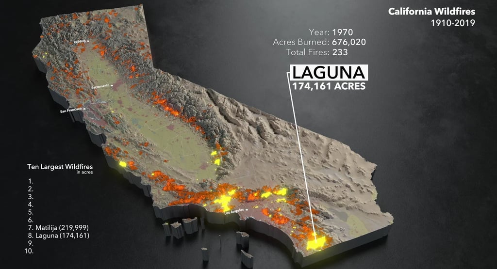
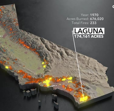
- 1970 Laguna Fire in San Diego County: 175,000+ acres, hundreds of structures lost.
- 1985 Wheeler Fire in Ventura: 122,000+ acres.
- 1993 firestorm: Multiple fires (Old Topanga, Green Meadows, Laguna) destroyed over 1,000 homes across six counties in a single October week.
These events revealed a pattern: Santa Ana winds (katabatic, dry, gusting 50–80+ mph) drive rapid spread in October–December, the peak danger window. Human causes dominated—power lines, equipment, arson, campfires—while lightning is rare in the south.
The 21st Century: Mega-Fires, Climate Amplification, and Record Destruction (2000–Present)
The new millennium brought unprecedented scale and destructiveness, driven by hotter, drier conditions linked to climate change, invasive grasses increasing fine fuels, and continued WUI growth.
Standouts:
- 2003 Cedar Fire (San Diego County): 273,246 acres, 2,820 structures destroyed, 15 deaths. At the time, California’s largest modern fire; started by a lost hunter’s signal fire.
- 2007 fire siege: Multiple blazes, including Witch Fire (merged with others), burned hundreds of thousands of acres and destroyed thousands of homes.
- 2017 Thomas Fire (Ventura/Santa Barbara): 281,893 acres, 1,063 structures, 23 deaths. One of the largest by acreage; its smoke affected air quality across the West.
- 2018 Woolsey Fire (Ventura/Los Angeles): 96,949 acres but devastated Malibu and surrounding areas, destroying 1,643 structures.
- January 2025 Palisades and Eaton Fires (Los Angeles County): Among the most destructive in state history for structures lost (thousands combined, with Palisades and Eaton ranking high on Cal Fire’s lists). Fueled by extreme winds and drought-stressed vegetation, they ravaged Pacific Palisades, Eaton Canyon, and beyond, becoming symbols of urban conflagration vulnerability. These events, part of a broader January siege, prompted major independent analyses and renewed policy focus.
Since 2000, California’s annual burned acreage has swung wildly, with peaks exceeding 4 million acres statewide in 2020. Southern California’s share often involves fewer total acres than the north but far higher structure losses and human impacts due to dense population.
Underlying Drivers and Evolving Management
Causes: ~90%+ human ignitions. Santa Ana winds are the great accelerator. Climate change has extended fire seasons, reduced snowpack, and increased vapor pressure deficit (drier air sucking moisture from plants).
Ecological Impacts: Chaparral is fire-adapted (many species require smoke or heat for germination), but too-frequent fires (now every 10–20 years in places vs. historical 30–100+) convert shrublands to invasive grasslands. Wildlife suffers short-term; long-term recovery depends on burn severity.
Human and Economic Toll: Billions in suppression costs, insured losses, and indirect damages (air quality, tourism). Displacement of tens of thousands. Psychological trauma in fire-prone communities.
Management Evolution: The 20th-century “put it out by 10 a.m.” policy gave way in the 1970s–80s to “let it burn” in remote areas and prescribed fire. Today, there is growing embrace of Indigenous cultural burning practices, with tribes leading revitalization efforts. Programs emphasize defensible space, home hardening (e.g., ember-resistant vents), early warning systems, and utility wildfire mitigation (covered power lines, Public Safety Power Shutoffs). Yet challenges remain: regulatory hurdles for prescribed burns, liability concerns, and funding.
Living with Fire: Lessons from the Past for the Future
Southern California’s wildfire history is not a story of inevitable doom but of adaptation. Indigenous peoples lived sustainably with fire for millennia. Early settlers learned its power the hard way. Modern society, with vastly more at stake in the WUI, must do the same—through science-informed policy, community resilience, and a return to “good fire” principles.
As we face longer, hotter fire seasons, the lesson is clear: Fire is not the enemy; mismanagement of it is. By honoring the land’s natural rhythm, hardening our homes and communities, and working across agencies, tribes, and residents, Southern California can reduce catastrophe while preserving the wild beauty that defines it.
The flames have written this region’s history for thousands of years. How we read and respond to that record will determine the chapters yet to come.
Sources drawn from Cal Fire records, historical chronologies (e.g., UC ANR), peer-reviewed reconstructions (Santa Barbara Basin sediments, USGS analyses), Wikipedia compilations of official data, and contemporary accounts. Acreage and impact figures are approximate based on official reports; debates over early sizes reflect the limitations of pre-modern documentation.
This history reminds us that while the fires may grow larger and more destructive in a changing climate, the solutions lie in understanding the deep past and applying it wisely today. Stay safe, prepare, and respect the flame.