Fire Behavior Modeling Sounds Smart—But...
Fire Behavior Modeling Sounds Smart—But for Southern California Homeowners, It’s Often Just Expensive Graphs. Here’s Where Your Time and Money Actually Belong.

If you live in Southern California or anywhere in the wildland-urban interface (WUI)—you’ve probably felt the annual anxiety as Santa Ana winds kick up and fire season looms.
After the devastating 2025 Eaton and Palisades Fires (and too many others before them), homeowners are bombarded with new tech promises: AI-driven fire behavior models, parcel-level risk maps, “fire pathway” simulations, and glossy reports that claim to tell you exactly how a wildfire will hit your specific home.
Companies like XyloPlan lead this space. Their Fire Pathways™ technology models ember travel, structure-to-structure spread, wind-driven fire movement, and parcel-level exposure. It’s sophisticated. It integrates real-time data. And it produces beautiful visualizations.
But here’s the uncomfortable truth for most individual homeowners: Spending thousands of dollars on these models often delivers far less practical protection than rolling up your sleeves and doing the basics right now.
What Fire Behavior Modeling Actually Delivers (and for Whom)
These tools shine where they were designed: helping fire agencies, incident commanders, insurers, and large-scale planners make better decisions.
At the recent Western Fire Chiefs Association IGNITE Symposium, XyloPlan and partners (Fire Aside, Earth Fire Alliance, and Tablet Command) demonstrated exactly this. Led by Dave Winnacker (retired fire chief and XyloPlan co-founder), they walked through a realistic scenario of a fast-moving, wind-driven fire.
> “Each of us built something different. Together, we showed what's possible when those pieces connect.
> The scenario we walked through was the one that keeps fire chiefs up at night: a fast-moving, wind-driven fire. The kind where the first 30 minutes determine everything. …
> Fire Aside collected home hardening assessments and defensible space data at the parcel level. Earth Fire Alliance provided real-time fire spread detection. XyloPlan pulled those two streams together — fire behavior data from Earth Fire Alliance, structure-level hardening data from Fire Aside — and produced a comprehensive view of urban fire spread potential. That intelligence fed directly into Tablet Command, putting a sharper, more complete operational picture in front of the incident commander before the first unit arrived on scene.
> This isn't a product integration story. It's a workflow story. Fire agencies have always had pieces of this data. What they've been missing is a connected path from that data to a better-informed initial attack.
> That path exists now.”
This is genuinely impressive work for the professionals on the front lines. It can help crews prioritize initial attack, guide fuel breaks, and inform community-level mitigation. Insurers are already using similar modeling (XyloPlan partners with firms like Mercury Insurance) to refine risk scores and pricing.
But notice what the demo was not about: helping you, the individual homeowner, survive a fire on your property.
The Homeowner Reality Check
A detailed fire behavior report might show colorful heat maps of ember cast or predicted flame lengths reaching your roofline. It might even suggest prioritized vegetation treatments. That sounds valuable—until you realize:
- It’s still a prediction, not a guarantee. Wildfires in Southern California are chaotic. Extreme winds, ember showers that jump a mile, and structure-to-structure ignition (where one house lights the next) make precise modeling extremely difficult, even with the best data.
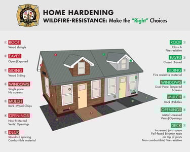
- It doesn’t harden your home. The model can’t install ember-resistant vents, replace your roof with Class A materials, or clear the critical 0–5 foot “Zone 0” around your foundation.
- It doesn’t create defensible space. You still have to do the work: removing dead vegetation, pruning trees, and maintaining the 30-foot and 100-foot zones CAL FIRE recommends.
- The cost-benefit for one house is questionable. While exact homeowner pricing isn’t publicly listed (these platforms are mostly sold to agencies, counties, and insurers), similar detailed risk assessments and custom modeling reports easily run into the thousands. That money could instead fund real retrofits, insurance premiums, or community fuel reduction projects.
Recent studies back this up. Post-fire analyses (including work from UC Berkeley researchers and the Insurance Institute for Business & Home Safety) show that homes with good defensible space and basic hardening survive at dramatically higher rates—often doubling survival odds even in intense wind-driven fires. The biggest predictor isn’t the model’s risk score. It’s whether the house was ignition-resistant when embers arrived.
What Southern California Homeowners Should Actually Do (and Why It Works Better)
Your time and budget are limited. Prioritize what moves the needle most:
1. Defensible Space (Start here—it’s mostly free)
Zone 0 (0–5 ft): Clear all combustible material right up to the house.
Zone 1 (5–30 ft): Low, irrigated, fire-resistant plants; no trees touching the structure.
Zone 2/3 (30–100+ ft): Thin and prune to slow fire spread.
Do it yourself or hire a crew. Many fire departments and nonprofits offer free or low-cost inspections.
2. Home Hardening (The highest-ROI investments)
- Ember-resistant vents and eaves
- Class A roofing and rain gutters with spark arrestors
- Dual-pane windows with metal screens
- Stucco or fiber-cement siding
3. Insurance and evacuation readiness
Shop carriers that reward mitigation (some now use the very models we’re discussing to offer better rates for prepared homes). Build a go-bag, know your evacuation routes, and have a family plan.
4. Community-level action
Push your HOA or city for shared fuel breaks and coordinated hardening programs. That’s where agency-focused tools like XyloPlan’s actually help scale real protection.
Bottom Line: Preparation Beats Prediction
Fire behavior modeling is a powerful tool—for fire chiefs, incident commanders, and insurers trying to manage risk at scale. The IGNITE Symposium demo proves the industry is getting better at connecting the dots for professional responders.
But for you as a Southern California homeowner, the data is clear: fancy graphs won’t stop embers from finding a gap under your eaves. Action will.
Don’t let marketing hype distract you from the proven fundamentals. Spend your limited time and money where it delivers the biggest difference between your home standing or becoming another statistic.
The fire is coming. The question isn’t whether the model predicted it accurately. The question is whether your house was ready when it arrived.