Essential Tech Tools and Strategies for Public Monitoring Wildfires Fires
Staying Ahead of Southern California's Wind-Driven Wildfires: Essential Tech Tools and Strategies for Public Monitoring
Staying Ahead of Southern California's Wind-Driven Wildfires: Essential Tools and Strategies for Public Monitoring
Wind-driven wildfires pose a unique and devastating threat to Southern California, fueled by powerful seasonal winds like the Santa Ana and Diablo winds. These events can turn a small spark into a raging inferno within hours, as seen in historic blazes like the Thomas Fire or the more recent 2025 Los Angeles County fires. With dry vegetation, steep terrain, and gusts exceeding 50 mph, staying informed isn't just helpful—it's essential for safety and preparedness. This guide equips you with the knowledge to monitor fire weather and leverage public-accessible technologies to track wildfires in real-time.
Understanding Fire Weather in Southern California
Fire weather refers to atmospheric conditions that influence wildfire ignition, spread, and intensity. In SoCal, the focus is on wind-driven scenarios where low humidity, high temperatures, and strong offshore winds create perfect storm conditions for rapid fire growth.
Key Fire Weather Phenomena
- Santa Ana Winds: These northeasterly winds originate from high-pressure systems over the Great Basin, funneling dry, warm air through mountain passes into coastal areas. They typically peak from October to March, with gusts up to 80 mph, desiccating fuels and pushing flames at alarming speeds. Humidity can drop below 10%, making vegetation highly flammable.
- Red Flag Warnings: Issued by the National Weather Service (NWS) when critical fire weather conditions are imminent, such as sustained winds over 15 mph, humidity under 25%, and dry fuels. These warnings signal heightened risk and often precede evacuations.
How to Monitor Fire Weather
Start by tracking forecasts and real-time data to anticipate threats. Here's how:
1. National Weather Service Tools: The NWS provides Fire Weather Outlooks for up to eight days ahead, highlighting areas at risk for significant wildfires based on fuel conditions and weather. Access them via the NWS website or apps like MyRadar, which overlays weather layers including wind speeds, temperatures, and warnings on interactive maps.
2. Santa Ana Wildfire Threat Index (SAWTI): This free tool from the U.S. Forest Service rates Santa Ana wind events on a scale from "No Rating" (minimal threat) to "Extreme" (fires grow rapidly and are hard to control). It forecasts up to six days out, combining wind strength, fuel moisture, and event descriptions. Check daily updates on their dashboard for SoCal-specific zones. To implement: Visit fsapps.nwcg.gov/psp/sawti and bookmark it for quick access during wind seasons.
3. FWAS – Fire Weather Alert System App: A mobile app that sends customizable alerts for red flag warnings, fire weather watches, wind advisories, and more. It monitors nearby weather stations for thresholds like high winds or low humidity, and provides zone-specific forecasts. Download from Google Play or the App Store, set your location to SoCal (e.g., Los Angeles or Orange County), and configure notifications for wind gusts over 30 mph.
4. WindNinja App: For detailed wind modeling, this app simulates local wind flows over terrain, helping predict how Santa Ana winds might accelerate fire spread in canyons or hills. It's useful for hikers or residents in rugged areas; input your coordinates for forecasts.
Integrate these by checking SAWTI in the morning and enabling app alerts for immediate updates. During a red flag event, avoid outdoor activities that could spark fires, like using power tools.
Public Technologies for Wildfire Monitoring
Beyond weather, technology empowers the public to actively watch for and respond to wildfires. These tools aggregate data from satellites, cameras, sensors, and official sources, making professional-grade info accessible via apps and websites. Focused on SoCal's wind-driven fires, here are standout options:
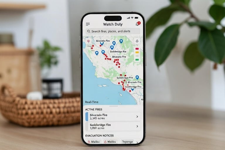
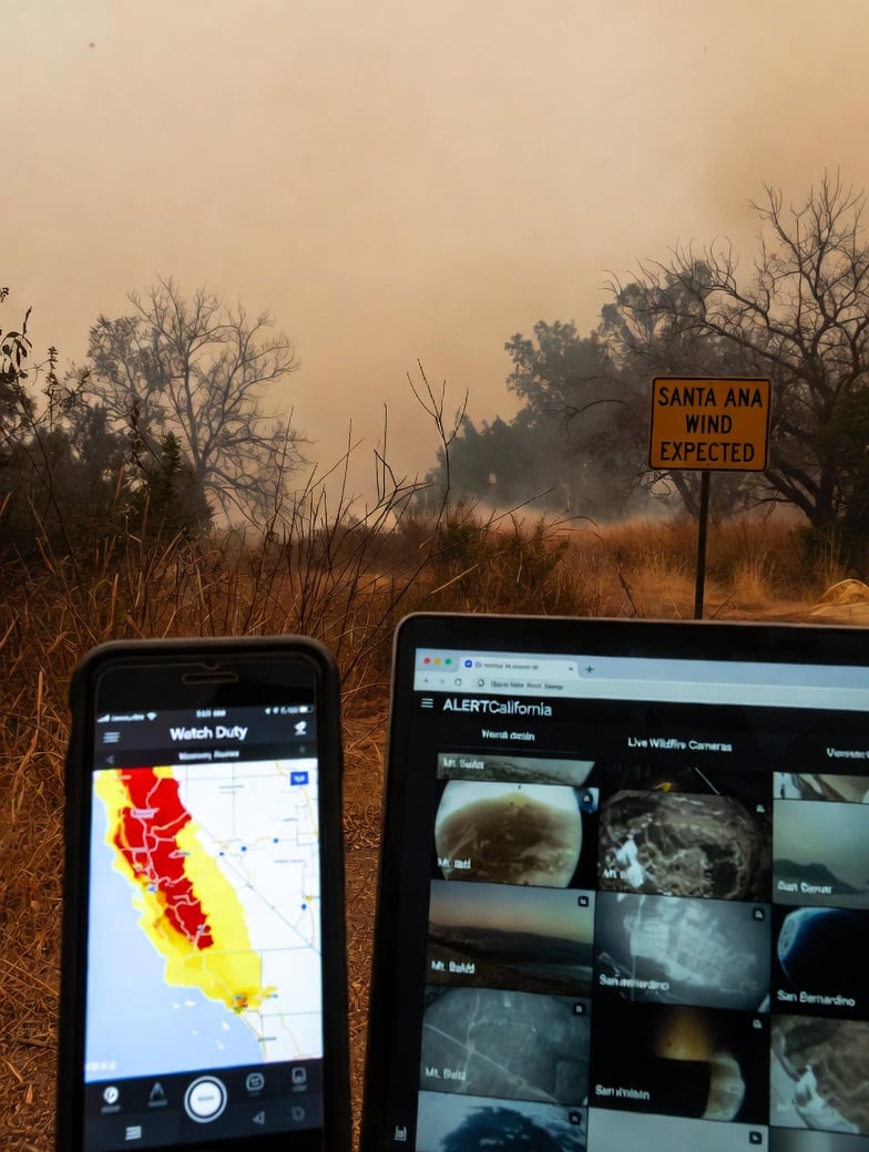
1. Watch Duty App
Launched in 2021 by Northern California tech entrepreneurs, Watch Duty has become a go-to for real-time wildfire intel, especially during SoCal's 2025 fires where it served millions. This nonprofit app centralizes data from radio scanners, wildfire cameras, satellites, and official agencies like Cal Fire.
- Features: Interactive maps showing fire perimeters, evacuation zones, wind direction, air quality index (AQI), and aircraft tracking. Get push notifications for threats to life or property, including wind-fueled spread.
- SoCal Relevance: During wind events, it overlays surface winds and red flag warnings, helping track how Santa Anas push fires toward urban areas like San Clemente or LA.
- Implementation: Download for free on iOS or Android. Create an account, set your location, and enable alerts for nearby fires. For $25/year membership, unlock advanced features like flight paths. Volunteers (including retired firefighters) monitor 24/7, ensuring accuracy.
2. ALERTCalifornia Camera Network
Managed by UC San Diego in partnership with Cal Fire, this system deploys over 1,100 AI-powered cameras across California for early detection. Public access allows viewing live feeds to spot smoke plumes during windy conditions.
- Features: High-definition cameras on mountaintops detect smoke via AI, providing 360-degree views. Includes sensors for wind and humidity.
- SoCal Relevance: Cameras cover high-risk areas like the San Gabriel Mountains, where Santa Ana winds amplify fires. Used in real-time during 2025 LA blazes.
- Implementation: Visit alertcalifornia.org, search for SoCal cameras (e.g., near Malibu or Ventura), and stream live. No app needed, but pair with Watch Duty for integrated alerts. Report suspicious smoke via the site's tools.
3. Frontline Wildfire App
This free app focuses on personalized wildfire defense, ideal for wind-prone SoCal homes.
- Features: Custom alerts based on your address, including evacuation notices, red flag warnings, and lightning events. Includes preparation checklists for defensible space.
- SoCal Relevance: Tracks how winds drive fire toward communities, with maps showing potential spread.
- Implementation: Download on mobile, input your San Clemente address, and create a family group for check-ins. Use its tips to harden your home against embers carried by Santa Anas.
4. Fires: Wildfire News and Atlas App
A comprehensive tracker with 3D mapping for CalFire operations.
- Features: Real-time fire locations, perimeters, wind conditions, AQI, and aircraft tracking. Alerts for nearby blazes.
- SoCal Relevance: Visualizes wind-driven fire behavior in areas like Orange County.
- Implementation: Available on iOS; set watchlist locations and enable notifications for instant updates.
Additional Tools
- WIFIRE Edge: UCSD's platform for predictive fire modeling, using wind data for spread forecasts. Public versions offer maps via their site.
- OroraTech Satellite Monitoring: Provides near-real-time hotspot detection from space, useful for early wind-fueled ignitions. Access via their platform for global views, zoomed to SoCal.
- FireSafe Bot: Social media alerts for California outbreaks; follow on platforms like Twitter for instant notifications.
Implementing These Solutions: Step-by-Step Guide
1. Assess Your Risk: Use SAWTI and NWS to identify wind event days. Check fuel moisture levels—if low, prepare evacuation kits.
2. Download and Customize Apps: Install Watch Duty, FWAS, and Frontline. Set locations to your area (e.g., San Clemente IP suggests coastal focus), enable geolocation, and customize alerts for wind speeds >25 mph or humidity <20%.
3. Daily Monitoring Routine: Morning: Review SAWTI and NWS outlooks. Afternoon: Scan ALERTCalifornia cameras for smoke. Evening: Check app maps for active fires.
4. Community Integration: Join local alert systems like Genasys Protect (formerly Zonehaven) for county-specific evacuations. Share app insights with neighbors via group chats.
5. Preparation Tips: Create defensible space by clearing vegetation 100 feet from your home. Install wind-resistant vents to block embers. Test tools during non-emergency periods.
By combining these technologies, you transform from passive observer to informed guardian. In a region where winds can change everything in minutes, knowledge is your best defense. Stay vigilant, and remember: early detection saves lives. For more, explore the cited sources and official sites.
List of Acronyms and Definitions:
- AQI: Air Quality Index – A measure of how polluted the air currently is or how polluted it is forecast to become, often impacted by wildfire smoke.
- Cal Fire: California Department of Forestry and Fire Protection – The state agency responsible for fire protection and emergency response in California.
- FWAS: Fire Weather Alert System – A mobile app that provides customizable alerts for fire weather conditions like high winds and low humidity.
- IP: Internet Protocol (address) – In the article's context, refers to the user's IP address used to infer location (e.g., San Clemente).
- LA: Los Angeles – A major city and county in Southern California prone to wind-driven wildfires.
- NWS: National Weather Service – The U.S. federal agency that provides weather forecasts, warnings, and fire weather outlooks.
- SAWTI: Santa Ana Wildfire Threat Index – A forecasting tool that rates the potential severity of Santa Ana wind events for wildfire risk.
- SoCal: Southern California – The region encompassing areas like Los Angeles, Orange County, and San Diego, known for wind-driven wildfires.
- UC San Diego: University of California, San Diego – A university involved in wildfire research and tools like ALERTCalifornia and WIFIRE.
All Sources
1. Citation ID: 0 – Watch Duty - Wildfire Maps & Alerts
URL: [https://www.watchduty.org/](https://www.watchduty.org/)
Description: Official site for the Watch Duty app, detailing real-time wildfire maps, alerts, and features.
2. Citation ID: 3 – What Is 'Watch Duty' and How Does the App Track Wildfires?
Description: Overview of Watch Duty's launch in 2021 and its role in tracking wildfires, including 2025 events.
3. Citation ID: 5 – Watch Duty app is revolutionizing how residents, firefighters stay updated on wildfires
URL: [https://www.youtube.com/watch?v=bAUaurgGzP8](https://www.youtube.com/watch?v=bAUaurgGzP8)
Description: Video explanation of how Watch Duty aggregates wildfire updates, relevant to 2025 Southern California fires.
4. Citation ID: 8 – Watch Duty App puts wildfire information one click away
Description: Details on Watch Duty's volunteer monitoring and app features.
5. Citation ID: 9 – Wildfire Alerts app brings real-time wildfire information to all US states
Description: Coverage of Watch Duty's expansion and membership options.
6. Citation ID: 11 – What to know about Watch Duty app amid Eaton, Palisades fires
Description: Relevance of Watch Duty to Southern California wind-driven fires like those in 2025.
7. Citation ID: 15 – Five Useful Apps for Wildfire Readiness
Description: Mentions FireSafe Bot for social media alerts in California.
8. Citation ID: 17 – ALERTCalifornia AI wildfire camera network replaces human lookout towers across California
Description: Details on ALERTCalifornia's role in 2025 LA fires and WIFIRE integration.
9. Citation ID: 18 – Fires: Wildfire News and Atlas
Description: App Store page for the Fires app, highlighting 3D mapping and alerts.
10. Citation ID: 21 – UC San Diego's WIFIRE Program Provides Real-Time Information to Wildfire Responders
Description: Overview of WIFIRE's predictive modeling for wildfires.
11. Citation ID: 22 – How It Works
URL: [https://www.watchduty.org/how-it-works/overview](https://www.watchduty.org/how-it-works/overview)
Description: Explanation of Watch Duty's monitoring process using scanners and cameras.
12. Citation ID: 23 – Frontline Wildfire Tracker
Description: App Store details for Frontline Wildfire app features.
13. Citation ID: 25 – OroraTech: The leading wildfire management platform globally
URL: [https://ororatech.com/](https://ororatech.com/)
Description: Official site for OroraTech's satellite-based hotspot detection.
14. Citation ID: 26 – Wildfire App | Frontline
Description: Frontline app's features for personalized alerts and preparation.
15. Citation ID: 29 – ALERTCalifornia: Home
URL: [https://alertcalifornia.org/](https://alertcalifornia.org/)
Description: Official site for the ALERTCalifornia camera network.
16. Citation ID: 30 – Santa Ana Winds Threat Index (SAWTI) and Red Flag Warnings Dashboard
Description: Dashboard for SAWTI forecasts.
17. Citation ID: 31 – FWAS–Fire Weather Alert System
Description: App Store page for FWAS alerts.
18. Citation ID: 33 – Santa Ana Wildfire Threat Index
URL: [https://fsapps.nwcg.gov/psp/sawti](https://fsapps.nwcg.gov/psp/sawti)
Description: Official SAWTI tool and ratings.
19. Citation ID: 35 – WindNinja Mobile
Description: App for wind modeling; also references MyRadar for weather overlays.
20. Citation ID: 36 – Fire Weather
URL: [https://www.weather.gov/fire](https://www.weather.gov/fire)
Description: NWS fire weather outlooks and red flag warnings.
21. Citation ID: 37 – Wildfire Detection & Risk Product Suite - FireSafe AI
URL: [https://firesafe.live/products](https://firesafe.live/products)
Description: Details on FireSafe Bot for alerts.
22. Citation ID: 38 – Santa Ana Winds Wildfire Threat Index | U.S. Climate Resilience Toolkit
Description: Explanation of Santa Ana winds and their fire weather impacts.